Model and Diagrams of the Ara Pacis
Ground Plans and Elevations
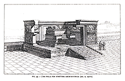
The base of the original monument was first fully uncovered and recorded during the major 1936-37 excavation. This provided the essential footprint for the 1938 restoration of the Ara Pacis and for all further study, as in the groundplans below. Drawings and prints in Moretti's 1948 landmark publication continue to provide some of the most informative drawings and diagrams.
TO ZOOM IN ON THE LARGE IMAGES, USE THE BUTTONS AT TOP-LEFT.
- Pages:
- « previous
- 1
- 2
- next »
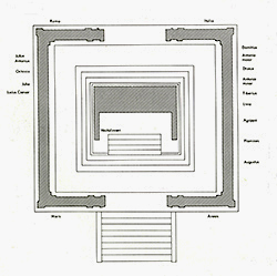
Fig. 28 "Ara Pacis groundplan". Scanned from Erika Simon, Augustus: Kunst und Leben in Rom um der Zeitenwende; Munich, 1986, fig.28. Courtesy Hirmer Verlag, München. Reproduced with appreciation.
|
Scanned from Wayne Andersen, The Ara Pacis of Augustus and Mussolini: An Archaeological Mystery. Geneva and Boston: Èditions Fabriart, 2003. Courtesy author; reproduced with appreciation. |
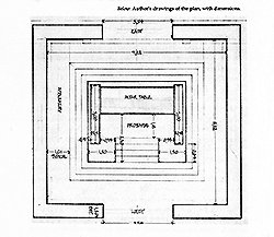
Scanned from Amanda Claridge, Rome, an Oxford Archaeological Guide, Oxford University Press, 2nd ed., 2008, p. 214; drawn by the author. Courtesy author; reproduced with appreciation.
|
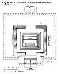
Scanned from Giuseppe Moretti, L'Ara Pacis Augustae; Rome, 2005 (ist ed. La Libreria dello State, 1948), vol.2, fig. 99. Courtesy of the Istituto Poligrafico e Zecca dello Stato, Rome. Reproduced with appreciation.
|
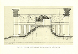
"Plate 6 - Longitudinal section of the reconstructed monument". Scanned from Giuseppe Moretti, L'Ara Pacis Augustae, Rome: Istituto Poligrafico e Zecca dello Stato S.p.A., 2005, 2 vols. (1st ed. La Libreria dello Stato, 1948). Courtesy of the Istituto Poligrafico e Zecca dello Stato, Rome. Reproduced with appreciation.
|
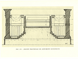
"Plate 7 - Cross section of the reconstructed monument". Scanned from Giuseppe Moretti, L'Ara Pacis Augustae, Rome: Istituto Poligrafico e Zecca dello Stato S.p.A., 2005, 2 vols. (1st ed. La Libreria dello Stato, 1948). Courtesy of the Istituto Poligrafico e Zecca dello Stato, Rome. Reproduced with appreciation.
|
- Pages:
- « previous
- 1
- 2
- next »