Drawings, Print, and 20th C. Photographs
1897 - Lanciani
This 1897 book by Rodolfo Lanciani, the leading authority of the time on the archaeology of ancient Rome, was a major advance over all previous guidebooks to the ancient city and remains an impressive achievement even today. By 1878 Lanciani had been placed in charge of all excavations in Rome and had been appointed Professor of Roman Topography at the University of Rome. His scholarship in his book and elsewhere is noteable for it historical accuracy and detail. This book is not a translation but was written in clear English for the British publisher. Lanciani was fluent in English as well as Italian. These exemplary maps are based on up-to-date research, drawn by Lanciani especially for this publication. They include THE FIRST PUBLISHED MAP SHOWING THE LOCATION OF THE ARA PACIS (FIG. 173 BELOW). There are also 2 of the first published photographs of any portion of the Ara Pacis (figs. 469 and 470 below).
Scanned from Rodolfo Lanciani, The Ruins & Excavations of Ancient Rome: A Companion Book for Students and Travelers, London: Macmillan and Co., Ltd., 1897. Reproduced with appreciation.
The full text of this book, though with weekly reproduced maps, is on the web through questia.com.
TO ZOOM IN ON THE LARGE IMAGES, USE THE BUTTONS AT TOP-LEFT.
Tips for using this website
Rodolfo Lanciani, The Ruins & Excavations of Ancient Rome, 1897. Rodolfo Lanciani |
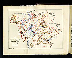
"Fig,1. Hydrography & Chorography of Ancient Rome". "Drawn by R. Lanciani"
|
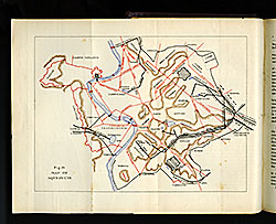
"Fig,19. Map of Aqueducts ". Drawn by R. Lanciani
|
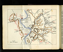
"Fig,24. Map of Walls ". Drawn by R. Lanciani
|
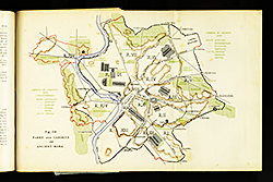
"Fig.150. Parks and Gardens of Ancient Rome". Drawn by R. Lanciani
|
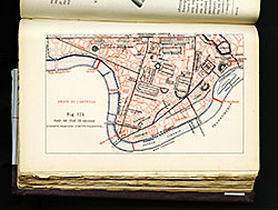
"Fig.173. Map of the IX Region (Campus Martius-Circus Flaminius.)" Drawn by R. Lanciani |
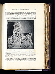
Page 469, "Fig. 183.-The Ara Pacis Augustae-details." |
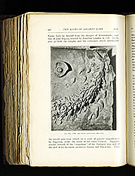
Page 470, "Fig. 184.-The Ara Pacis Augustae-details." |