return to Kabah Map and Categories

Palace Plaza
page: 1 2 | next page >

Click images below to enlarge. Images will open in new windows.
You may open two or more images for comparisons.
 

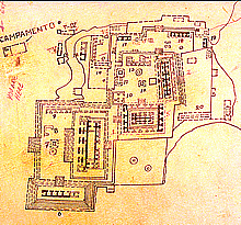
Detail of East Group on 1968 INAH map. The number 12 locates the altar in center of Palace Plaza, a ceremonial area. North at top.
Jan. 2002

Detail of Palace Plaza shown in map at left. The Palace at the right.
Jan. 2002
Central staircase from Lower Plaza up to Palace Plaza, with unusual shallow terraces between wall setbacks. In the center of photo we see the back of Structure 2C4, a slightly later addition.
 Jan. 2003 (24mm lens)
 Palace Plaza: 3 photos looking from left to right. In this photo, we are looking southwest past the ceremonial platform with altar. The Elite Residence 2C3 is at left with the back of the Codz Poop in the distance.
Jan. 2001
 Palace Plaza: 3 photos looking from left to right. Altar here is at lower right of photo. In center of photo is Structure 2C4, a slightly later addition.
Jan. 2001
 Palace Plaza: 3 photos looking from left to right. In this photo we are looking northwest down axis of Palace Plaza.
Jan. 2001
Looking northeast across Palace Plaza to structure 2C5, Palace at right.
 Jan. 2003 (24mm lens)
Looking northwest past ceremonial platform with altar, Palace at right.
 Jan. 2003 (24mm lens)
Looking northwest across chultune ring to ceremonial platform with altar.
Jan. 2001
Ceremonial platform with altar in center of Palace Plaza.
Jan. 2002
Same altar, no remaining carving.
Jan. 2001
Stone ring from mouth of chutune.
Jan. 2001
page: 1 2 | next page >
 

return to Kabah Map and Categories