 |
Detail of East Group from 1968 INAH map. Codz Poop at right, Platform in front of and around Codz Poop. Collapsed structure 2B3 at bottom.
Jan. 2002 |
|
 |
Looking southeast to north and west sides of Platform and Codz Poop above; also showing location of main staircase.
Jan. 2003 (24mm lens) |
|
 |
Northeast corner of Codz Poop Platform, on higher ground so less tall than northwest corner. Corner reconstructed, northeast corner of Codz Poop largely collapsed.
Jan. 2002 |
|
 |
Northwest corner, showing platform built upon natural rock outcropping, a common practice in Puuc region.
Jan. 2003 (24mm lens) |
|
 |
Northwest corner with slightly recessed walls, the usual practice.
Jan. 2001 |
|
 |
Northwest corner with
slightly recessed walls, natural rock outcropping at left.
Jan. 2001 |
|
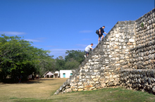 |
Tourists climbing steep main (west) staircase
to top of Codz Poop Platform.
Jan. 2001 |
|
 |
Local guide climbing same staircase on
the diagonal, much the easiest method.
Jan. 2001 |
|
 |
Main, central (west) staircase, lined up with
central door of Codz Poop; altar on ground level, not centered.
Nov. 1999 |
|